
Dease: Regional Summary
Land Stations
[ Buoys ]
| Wind(knots) | Conditions | Visibility(km) | Pressure(kPa) | Air temp(°C) | Relative humidity(%) | Dew point(°C) | Wind Chill |
|---|---|---|---|---|---|---|---|
| Aklavik Airport 04:00 AM MDT 16 October 2026 | |||||||
| N 1 | N/A | N/A | 101.0 | -3 | 99 | -3 | -4 |
| Bathurst Inlet 04:00 AM MDT 16 October 2026 | |||||||
| S 7 | N/A | N/A | 102.8 | -9 | 83 | -11 | -15 |
| Cape Peel West 04:00 AM MDT 16 October 2026 | |||||||
| E 4 | N/A | N/A | N/A | -13 | 85 | -15 | -18 |
| Fort Chipewyan Airport 04:00 AM MDT 16 October 2026 | |||||||
| S 6 | Clear | 16 | 101.5 | 5 | 69 | 0 | * |
| Fort Good Hope Airport 04:00 AM MDT 16 October 2026 | |||||||
| ENE 5 | N/A | N/A | 100.7 | 1 | 91 | -1 | * |
| Fort McPherson Airport 04:00 AM MDT 16 October 2026 | |||||||
| NW 6 | N/A | N/A | 100.9 | -4 | 96 | -4 | -8 |
| Fort Providence 04:00 AM MDT 16 October 2026 | |||||||
| SSE 2 | N/A | N/A | 101.2 | -1 | 91 | -2 | -2 |
| Fort Resolution Airport 04:00 AM MDT 16 October 2026 | |||||||
| SSE 2 | N/A | N/A | 101.3 | 2 | 81 | -1 | * |
| Fort Simpson Airport 04:00 AM MDT 16 October 2026 | |||||||
| ESE 5 | Mainly Clear | 24 | 101.0 | 1 | 81 | -2 | * |
| Gateshead Island 04:00 AM MDT 16 October 2026 | |||||||
| NW 13 | N/A | N/A | 102.6 | -13 | 88 | -14 | -22 |
| Hay River/Merlyn Carter Airport 04:00 AM MDT 16 October 2026 | |||||||
| SSE 4 | Partly Cloudy | 24 | 101.3 | 3 | 78 | -1 | * |
| Inner Whaleback Rocks 04:00 AM MDT 16 October 2026 | |||||||
| SE 15 | N/A | N/A | 101.3 | 7 | 79 | 3 | * |
| Inuvik Airport 04:00 AM MDT 16 October 2026 | |||||||
| ENE 10 | Light Snow | 24 | 101.0 | -2 | 97 | -3 | -8 |
| Ivvavik National Park 03:00 AM MST 16 October 2026 | |||||||
| 1 | N/A | N/A | 101.2 | -13 | 86 | -15 | -14 |
| Kugluktuk Airport 04:00 AM MDT 16 October 2026 | |||||||
| ESE 12 | Clear | 24 | 102.2 | -6 | 76 | -10 | -14 |
| Norman Wells Airport 04:00 AM MDT 16 October 2026 | |||||||
| ESE 9 | Partly Cloudy | 48 | 100.7 | 2 | 85 | 0 | * |
| Sachs Harbour Airport 04:00 AM MDT 16 October 2026 | |||||||
| E 11 | N/A | N/A | 102.1 | -7 | 83 | -10 | -15 |
| Shingle Point Airport 03:00 AM MST 16 October 2026 | |||||||
| E 13 | N/A | N/A | N/A | -4 | 96 | -4 | -11 |
| Stefansson Island 05:00 AM CDT 16 October 2026 | |||||||
| W 13 | N/A | N/A | 102.5 | -16 | 80 | -18 | -26 |
| Stony Rapids Airport 04:00 AM CST 16 October 2026 | |||||||
| ESE 6 | Cloudy | 16 | 102.1 | 3 | 82 | 0 | * |
| Thomsen River 05:00 AM CDT 16 October 2026 | |||||||
| E 5 | N/A | N/A | 102.5 | -13 | 85 | -15 | -18 |
| Tuktoyaktuk Airport 04:00 AM MDT 16 October 2026 | |||||||
| ENE 10 | N/A | N/A | 101.2 | -3 | 94 | -4 | -9 |
| Tuktut Nogait National Park 04:00 AM MDT 16 October 2026 | |||||||
| SE 22 | N/A | N/A | 101.7 | -6 | 82 | -8 | -15 |
| Tulita Airport 04:00 AM MDT 16 October 2026 | |||||||
| ENE 7 | N/A | N/A | 100.8 | 0 | 94 | -1 | * |
| Ulukhaktok Airport 04:00 AM MDT 16 October 2026 | |||||||
| ESE 13 | N/A | N/A | 102.4 | -6 | 80 | -9 | -14 |
| Uranium City 04:00 AM CST 16 October 2026 | |||||||
| ESE 2 | N/A | N/A | 101.8 | 5 | 79 | 2 | * |
| Wrigley Airport 04:00 AM MDT 16 October 2026 | |||||||
| SE 5 | N/A | N/A | N/A | 0 | 85 | -2 | * |
| Łutselk'e Airport 04:00 AM MDT 16 October 2026 | |||||||
| E 7 | N/A | N/A | 101.7 | 3 | 84 | 1 | * |
If you require additional historical weather information, please visit Climate Data Online
[ Buoys ]
[ Land Stations ]
Zoom-in to make a selection
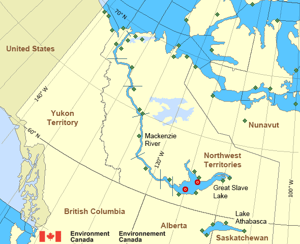
Legend:
 Buoy
 Land Station
Mackenzie - Mackenzie River Area
- Amundsen
- Axe Point mile 91 to Camsell Bend mile 290
- Baillie
- Banks
- Bathurst
- Bowie - northern half
- Byam
- Camsell Bend mile 290 to Tulita mile 512
- Coronation
- Dease
- Dixon Entrance East
- Dixon Entrance West - east of Langara
- Dixon Entrance West - west of Langara
- Dolphin
- Fort Good Hope mile 684 to Point Separation mile 913
- Great Slave Lake - basin
- Great Slave Lake - east arm
- Great Slave Lake - north arm
- Hecate Strait - northern half
- Lake Athabasca - eastern half
- Lake Athabasca - western half
- Larsen
- Mackenzie
- Maud
- McClintock
- McClure
- Melville
- North Mackenzie
- North Tuktoyaktuk
- Point Separation mile 913 to Kittigazuit Bay mile 1081
- Prince Alfred
- Prince of Wales
- Rae
- Tuktoyaktuk - northern half
- Tuktoyaktuk - southern half
- Tulita mile 512 to Fort Good Hope mile 684
- Ulukhaktok
- West Coast Haida Gwaii - northern half
- Wrigley Harbour mile 0 to Axe Point mile 91
- Yukon Coast
Another Region
- Date modified: