Language selection

Weather shortcuts

East Coast - Cape St. Francis and south

Forecast

Marine Forecast

Issued 03:00 AM NDT 11 August 2026

Today Tonight and Wednesday.

Wind south 10 to 15 knots increasing to south 15 to 20 this evening then backing to southeast 15 overnight. Wind veering to southwest 15 to 20 Wednesday afternoon.

Scattered showers and fog banks beginning early this morning.

Waves

Issued 06:00 AM NDT 11 August 2026
Today Tonight and Wednesday. Seas 1 to 2 metres.

Extended Forecast

Issued 03:00 AM NDT 11 August 2026
Thursday Wind west 20 knots.
Friday Wind south 10 to 15 knots.
Saturday Wind south 20 knots.

Stay connected

ATOM

Weather Conditions

Skip Image

Zoom-in to make a selection

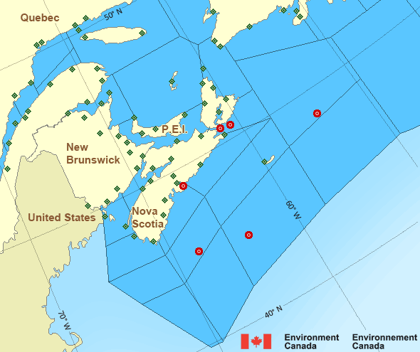
Map of Atlantic - Maritimes marine weather areas Baie-Comeau Airport Halifax Harbour - 44258 West Chedabucto Bay – 44489 North Cape Winterland Branch Hill Summerside Wreckhouse East Scotia Slope - 44137 Stephenville St. Lawrence Burgeo Havre-Saint-Pierre Airport Île aux Perroquets Île Rouge Longue-Pointe-de-Mingan Banquereau - 44139 Sept-Îles Airport Port aux Basques LaHave Bank - 44150 Sagona Island Mont-Joli Airport Beaver Island Baccaro Point St. Stephen Rivière-la-Madeleine Saint John Airport Gaspé Airport Point Lepreau Greater Moncton Roméo LeBlanc Int'l Airport Îles de la Madeleine Airport Miscou Island La Pocatière Kouchibouguac Cap-d'Espoir Grand Manan New Carlisle Fundy Park (Alma) Pointe-au-Père Miramichi Port Menier Charlo Île Bicquette Bathurst Airport Cap-Chat Bas Caraquet East Chedabucto Bay – 44488 Nappan AAFC East Point Charlottetown Airport Yarmouth Airport Pointe-Noire Western Head Tracadie J.A. Douglas McCurdy Sydney Airport Shearwater Airport St.Paul Island Sable Island Parrsboro North Mountain Pointe-des-Monts McNabs Island Lunenburg Kentville AAFC Ingonish Beach Hart Island CFB Greenwood Grand Étang Eskasoni (First Nations) Debert Caribou Point Brier Island
Legend:
buoy Buoy
land station Land Station
Ice Conditions

Ice Forecasts

Issued 10:00 AM EDT 7 August 2026 Forecasts have ended for the season.
 

Iceberg Bulletin

Issued 2:30 PM EDT 10 August 2026

Iceberg Limit

Iceberg limit at 0000 UTC 11 Aug estimated from Newfoundland near
4825N 5310W to 4840N 5220W to 5010N 5100W to 5325N 5100W to 5800N
5300W to 6020N 5200W to 5840N 4500W then eastward.

Iceberg Count

No confirmed icebergs except less than 10 icebergs northwest of the
iceberg limit.
Warnings

No watches or warnings in effect.

Synopsis

Technical Marine Synopsis

Issued 3:00 AM NDT 11 August 2026 Today Tonight and Wednesday At 3:00 a.m. NDT today trough located on a line northwest-southeast
over the Great Northern Peninsula.
By 3:00 a.m. NDT Wednesday trough located on a line
northwest-southeast over northern Belle Isle Bank.

At 3:00 a.m. NDT today ridge located over the northern Grand Banks.
By 8:00 p.m. NDT tonight departing ridge located east of the
Grand Banks.

At 3:00 a.m. NDT Wednesday approaching trough located on a line
northwest-southeast over the Gulf of St. Lawrence.

Atlantic - Maritimes Area

Another Region

Features

Colour-coded weather alerts

Learn more about weather alerting in Canada

Thunderstorm Outlooks

Find the Thunderstorm Outlook for your area.

Date modified: