Language selection

Weather shortcuts

Chaleur - Miscou

Forecast

Marine Forecast

Issued 08:00 PM ADT 04 September 2026

Tonight and Saturday.

Strong wind warning in effect.

Wind east 20 to 25 knots backing to northeast 30 near midnight. Wind northeast 30 Saturday.

Rain with a risk of thunderstorms this evening changing to scattered showers Saturday morning. Fog patches dissipating this evening.

Extended Forecast

Issued 03:30 PM ADT 04 September 2026
Sunday Wind northeast 25 to 35 knots.
Monday Wind north 25 knots.
Tuesday Wind northwest 25 knots.

Stay connected

ATOM

Weather Conditions

Skip Image

Zoom-in to make a selection

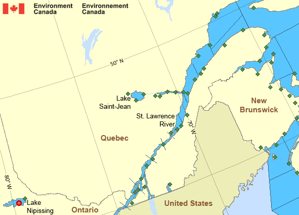
Map of St. Lawrence - St. Lawrence River marine weather areas Grand Manan New Carlisle Pointe-au-Père Fundy Park (Alma) Port Menier Miramichi Île Bicquette Charlo Cap-Chat Bathurst Airport CFB Bagotville Jonquière Mistook Normandin Roberval Airport Île-d'Orléans - Quai de St-Jean Deschambault North Bay Airport Beauport L'Isle-aux-Grues Bas Caraquet Lake Nipissing - 45152 Pointe-des-Monts L'Assomption Baie-Comeau Airport Saint-Anicet Cap-Rouge Sainte-Anne-de-Bellevue Lac Memphrémagog Montréal Metropolitain Airport Île Rouge Montréal-Trudeau Int'l Airport Lac Saint-Pierre Trois-Rivières Airport Pointe de l'Islet Pointe Claveau Sept-Îles Airport Kouchibouguac North Cape Pointe-Noire Yarmouth Airport Cap-d'Espoir Brier Island Rivière-la-Madeleine St. Stephen Gaspé Airport Saint John Airport Point Lepreau Greater Moncton Roméo LeBlanc Int'l Airport La Pocatière Miscou Island Mont-Joli Airport
Legend:
buoy Buoy
land station Land Station
Ice Conditions

Ice Forecasts

Issued 10:00 AM EDT 19 May 2026 Forecasts have ended for the season.
Warnings

Warnings (In effect)

Strong wind warning in effect

Chaleur - Miscou

Issued 9:25 PM ADT 04 September 2026

'Strong' winds of 20 to 33 knots are occurring or expected to occur in this marine area. Please refer to the latest marine forecasts for further details and continue to monitor the situation through Canadian Coast Guard radio.

Synopsis

Technical Marine Synopsis

Issued 8:00 PM ADT 4 September 2026 Tonight and Saturday At 8:00 p.m. ADT tonight intensifying low 1002 mb located over
Eastern Shore.
By 3:00 a.m. ADT Saturday low 998 mb located over Eastern Shore.

At 8:00 p.m. ADT Saturday quasi-stationary low 996 mb located over
southern Banquereau.

Marine Weather Statement

Issued 3:14 PM ADT 4 September 2026 A low pressure system over southwestern shore continues to intensify
and move slowly eastward today. Overnight this low is expected to lie
over eastern shore. The low will then stall over Southern Banquereau
Saturday evening.

Winds will increase to strong to gale force easterlies or
northeasterlies over northern and eastern marine areas. Over western
waters, winds will increase to strong northerlies on Saturday in the
wake of the low.

Marine interests are advised that gale warnings are in effect for
eastern shore, Sable, East Scotian Slope - western half, Fourchu,
Banquereau, Cabot Strait, Northumberland Strait and Gulf-Magdalen.

St. Lawrence - St. Lawrence River Area

Another Region

Features

Colour-coded weather alerts

Learn more about weather alerting in Canada

Improved storm alerts

Learn more about targeted warnings for severe thunderstorms and tornadoes

Date modified: