Language selection

Weather shortcuts

Gulf - Magdalen - northeastern half

Forecast

Marine Forecast

Issued 08:00 PM ADT 13 May 2026

Tonight and Thursday.

Wind southwest 15 to 20 knots diminishing to southwesterly 10 to 15 late overnight then backing to southeast 10 to 15 near noon Thursday. Wind increasing to southeast 15 to 20 early Thursday evening.

Waves

Issued 05:00 PM ADT 13 May 2026
Tonight and Thursday. Seas 1 to 2 metres subsiding to 1 or less late overnight.

Extended Forecast

Issued 03:30 PM ADT 13 May 2026
Friday Wind east 15 to 20 knots backing to northerly 15 to 20 in the afternoon.
Saturday Wind north 20 knots becoming southwest 15 to 20 late in the day.
Sunday Wind southwest 20 to 25 knots veering to northwest 25 to 30 late in the day.

Ice Forecast

Issued 10:00 AM EDT 13 May 2026 Today Tonight and Thursday Ice free. 

[ Canadian Ice Service ]

Stay connected

ATOM

Weather Conditions

Skip Image

Zoom-in to make a selection

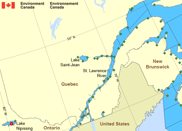
Map of St. Lawrence - St. Lawrence River marine weather areas Miramichi North Cape Port Menier Roberval Airport Normandin Mistook Jonquière CFB Bagotville Cap-Chat Île Bicquette Charlo North Bay Airport Yarmouth Airport Brier Island St. Stephen Saint John Airport Point Lepreau Greater Moncton Roméo LeBlanc Int'l Airport Miscou Island Kouchibouguac Kouchibouguac Grand Manan Fundy Park (Alma) Bas Caraquet Bathurst Airport Lac Saint-Pierre Pointe-Noire Île d'Orléans Pointe-des-Monts L'Assomption Sept-Îles Airport Pointe Claveau Pointe de l'Islet Trois-Rivières Airport L'Isle-aux-Grues Deschambault Île Rouge Montréal-Trudeau Int'l Airport Montréal Metropolitain Airport Lac Memphrémagog Sainte-Anne-de-Bellevue Cap-Rouge Saint-Anicet Baie-Comeau Airport La Pocatière Pointe-au-Père New Carlisle Mont-Joli Airport Gaspé Airport Lake Nipissing - 45152 Rivière-la-Madeleine Beauport Cap-d'Espoir
Legend:
buoy Buoy
land station Land Station
Ice Conditions

Ice Forecasts

Issued 10:00 AM EDT 13 May 2026 Today Tonight and Thursday

Ice Edge

Ice edge estimated from Quebec near 5012N 6046W to 4956N 6025W to
4956N 5959W to 5116N 5738W to Quebec near 5125N 5736W. Sea ice north
of the ice edge.

Ice Coverage

Ice free.


Iceberg Bulletin

Issued 3:19 PM EDT 13 May 2026

Iceberg Limit

Iceberg limit at 0000 UTC 14 May estimated from Newfoundland near
4655N 5545W to 4125N 5045W to 4135N 4645W to 4740N 4405W to 5310N
4635W to 5550N 5010W to 5900N 5500W to 6000N 5300W to 5840N 4940W to
5755N 4530W then northeastward.

Iceberg Count

No confirmed icebergs.
Warnings

Warnings (Ended)

Strong wind warning ended

Gulf - Magdalen - northeastern half

Issued 8:00 PM ADT 13 May 2026
Synopsis

Technical Marine Synopsis

Issued 8:00 PM ADT 13 May 2026 Tonight and Thursday At 8:00 p.m. ADT tonight ridge located over the Maritimes.
By 3:00 a.m. ADT Thursday ridge located from Anticosti Island to
Laurentian Fan.

At 3:00 a.m. ADT Thursday deepening low 1006 mb located southwest
of the Marine District.
By 8:00 p.m. ADT Thursday low 998 mb located near Georges Bank.

Marine Weather Statement

Issued 7:36 PM ADT 13 May 2026 A low pressure system will approach the marine district from the
southwest on Thursday. Increasing easterly winds throughout the day
will reach strong to gale force across southern waters north of the
low.

Marine interests are advised that gale warnings are in effect for
Georges Bank, LaHave Bank, West Scotian Slope, Sable, East Scotian
Slope and Laurentian Fan - southwestern half.

St. Lawrence - St. Lawrence River Area

Another Region

Features

Colour-coded weather alerts

Learn more about weather alerting in Canada

Date modified: