Language selection

Features

Weather shortcuts

North Channel

Forecast

Marine Forecast

Issued 05:00 AM EDT 18 August 2026

Today Tonight and Wednesday.

Strong wind warning in effect.

Wind southwest 10 knots increasing to southwest 15 near noon and to northwest 15 to 20 early this evening. Wind diminishing to northwest 10 late overnight then increasing to west 15 near noon Wednesday. Wind increasing to west 20 Wednesday afternoon then diminishing to northwest 15 Wednesday evening.

Showers this afternoon and this evening with a risk of thunderstorms.

Stay connected

ATOM

Weather Conditions

Skip Image

Zoom-in to make a selection

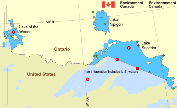
Map of Great Lakes - Lake Superior marine weather areas Royal Island Kenora Airport Sault Ste. Marie Airport Armstrong Airport Caribou Island Marathon Airport Pukaskwa National Park Wawa Airport Thunder Bay Airport Welcome Island Little Flatland Island Slate Island - 45136 Lake Of the Woods - 45148
Legend:
buoy Buoy
land station Land Station
Ice Conditions

*Ice Forecast and Warnings also apply to U.S. waters

Ice Forecasts

Issued 12:00 PM EDT 17 May 2026 Forecasts have ended for the season.
Warnings

Warnings (In effect)

Strong wind warning in effect

North Channel

Issued 05:00 AM EDT 18 August 2026

'Strong' winds of 20 to 33 knots are occurring or expected to occur in this marine area. Please refer to the latest marine forecasts for further details and continue to monitor the situation through Canadian Coast Guard radio.

Synopsis

There is no Synopsis issued for this area.

Great Lakes - Lake Superior Area

Another Region

Features

Colour-coded weather alerts

Learn more about weather alerting in Canada

Thunderstorm Outlooks

Find the Thunderstorm Outlook for your area.

Improved storm alerts

Learn more about targeted warnings for severe thunderstorms and tornadoes

Date modified: