
Committee
Forecast
Issued 05:30 AM EST 17 December 2024
Forecasts are unavailable until further request.
Stay connected
 ATOM
ATOMWeather Conditions
Zoom-in to make a selection
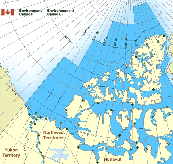
Legend:
 Buoy
Buoy  Land Station
 Ice Conditions
Ice Forecasts
Issued 10:00 AM EST 25 November 2024 Forecasts are unavailable until further request.Warnings
No watches or warnings in effect.
Synopsis
Technical Marine Synopsis
Issued 6:30 PM MST 17 December 2024 Forecasts are unavailable until further request.
Arctic - Western Arctic Area
- Admiralty
- Alert
- Amundsen
- Axel Heiberg
- Baillie
- Ballantyne
- Banks
- Barrow
- Bartlett
- Bathurst
- Boothia
- Borden
- Brock
- Byam
- Camsell Bend mile 290 to Tulita mile 512
- Clarence - northern half
- Clarence - southern half
- Committee
- Coronation
- CT4
- CU4
- CV4
- CV5
- CW3
- CW4
- CW5
- CX4
- Dease
- Dolphin
- East Baffin - northern half
- Ellef Ringnes
- Ellesmere
- Eureka - northern half
- Eureka - southern half
- Fitzwilliam
- Fort Good Hope mile 684 to Point Separation mile 913
- Greely
- Griper
- Gustaf
- Hassel
- Hazen
- Igloolik
- Jones - eastern half
- Jones - western half
- Kane - northern half
- Kane - southern half
- Lancaster - eastern half
- Lancaster - western half
- Larsen
- Liddon
- Mackenzie
- Maclean
- Massey
- Maud
- McClintock
- McClure
- Melville
- Nansen
- Navy Board
- Northwest Beaufort
- North Mackenzie
- North Prince Patrick
- North Sverdrup
- North Tuktoyaktuk
- Norwegian
- Peary
- Peel
- Point Separation mile 913 to Kittigazuit Bay mile 1081
- Pond
- Prince Alfred
- Prince of Wales
- Prince Patrick
- Queens
- Rae
- Regent
- Robeson - northern half
- Robeson - southern half
- Roes Welcome - northern half
- South Axel Heiberg
- South Ellef Ringnes
- South Prince Patrick
- South Sverdrup
- St. Roch
- Tuktoyaktuk - northern half
- Tuktoyaktuk - southern half
- Tulita mile 512 to Fort Good Hope mile 684
- Ulukhaktok
- Ward Hunt
- West Baffin - northern half
- West Baffin - southern half
- West Foxe
- West Prince Alfred
- Wilkins
- Yukon Coast
Another Region
- Date modified: