
Bathurst
Forecast
Marine Forecast
Issued 07:00 AM MDT 08 October 2026
Today Tonight and Friday.
Wind light increasing to south 15 knots early this afternoon and to northeast 20 near midnight. Wind northeast 20 Friday.
Periods of snow. Visibility as low as 1 mile in snow.
Temperatures near zero.
Waves
Issued 07:00 AM MDT 08 October 2026
Today Tonight and Friday.
Seas 1 metre or less.
Extended Forecast
Issued 07:00 AM MDT 08 October 2026
Saturday
Wind light increasing to south 20 knots in
the morning.
Sunday
Wind southwest 15 knots increasing to southwest
20.
Monday
Wind southwest 15 knots diminishing to
light.
Ice Forecast
Stay connected
 ATOM
Weather Conditions
Zoom-in to make a selection
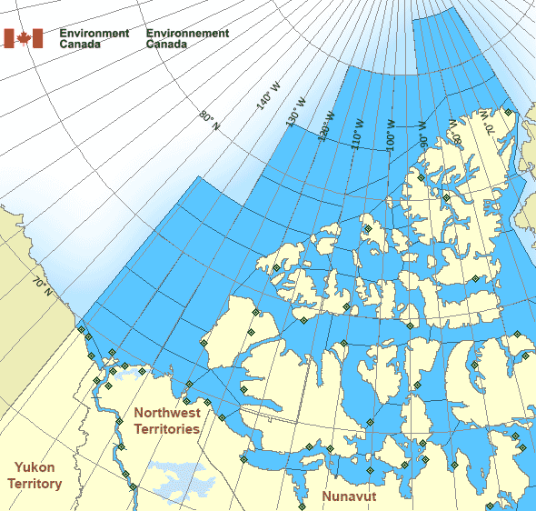
Legend:
 Buoy
 Land Station
Ice Conditions
Ice Forecasts
Issued 10:00 AM EDT 8 October 2026 Today Tonight and FridayIce Edge
First ice edge estimated from Melville Peninsula near 6802N 8555W to6818N 8625W to 6918N 8853W to 6951N 9054W to 7146N 9257W to Boothia
Peninsula near 7155N 9424W. Sea ice southwest of the ice edge.
Second ice edge estimated from Boothia Peninsula near 6844N 9430W to
Nunavut near 6818N 9552W. Sea ice southeast of the ice edge.
Third ice edge estimated from Tuktoyaktuk Peninsula near 6939N
13253W to Banks Island near 7157N 12514W. Sea ice northwest of the
ice edge.
Fourth ice edge estimated from Banks Island near 7123N 12119W to
7109N 12057W to Victoria Island near 7136N 11854W. Sea ice north of
the ice edge.
Fifth ice edge estimated from Victoria Island near 6940N 10139W to
6918N 10129W to 6920N 9859W to Prince of Wales Island near 7118N
9832W. Sea ice northwest of the ice edge.
Sixth ice edge estimated from Prince of Wales Island near 7234N
9624W to Somerset Island near 7233N 9519W. Sea ice north of the ice
edge.
Seventh ice edge estimated from Somerset Island near 7200N 9401W to
7159N 9340W to 7228N 9259W to Brodeur Peninsula near 7303N 8918W.
Sea ice northwest of the ice edge.
Eighth ice edge estimated from Brodeur Peninsula near 7121N 8953W to
7024N 8912W to 6955N 8701W to Baffin Island near 7000N 8547W. Sea
ice northeast of the ice edge.
Ice Coverage
Bergy water.
Warnings
No watches or warnings in effect.
Synopsis
Technical Marine Synopsis
Issued 6:30 AM MDT 8 October 2026 Today Tonight and Friday At 1200 UTC Thursday dissipating low 1006 mb located at 78N 75W.By 0000 UTC Saturday approaching high 1033 mb located at 70N 108W.
Arctic - Western Arctic Area
- Admiralty
- Alert
- Amundsen
- Axel Heiberg
- Baillie
- Ballantyne
- Banks
- Barrow
- Bartlett
- Bathurst
- Boothia
- Borden
- Brock
- Byam
- Camsell Bend mile 290 to Tulita mile 512
- Clarence - northern half
- Clarence - southern half
- Committee
- Coronation
- CT4
- CU4
- CV4
- CV5
- CW3
- CW4
- CW5
- CX4
- Dease
- Dolphin
- East Baffin - northern half
- Ellef Ringnes
- Ellesmere
- Eureka - northern half
- Eureka - southern half
- Fitzwilliam
- Fort Good Hope mile 684 to Point Separation mile 913
- Greely
- Griper
- Gustaf
- Hassel
- Hazen
- Igloolik
- Jones - eastern half
- Jones - western half
- Kane - northern half
- Kane - southern half
- Lancaster - eastern half
- Lancaster - western half
- Larsen
- Liddon
- Mackenzie
- Maclean
- Massey
- Maud
- McClintock
- McClure
- Melville
- Nansen
- Navy Board
- Northwest Beaufort
- North Mackenzie
- North Prince Patrick
- North Sverdrup
- North Tuktoyaktuk
- Norwegian
- Peary
- Peel
- Point Separation mile 913 to Kittigazuit Bay mile 1081
- Pond
- Prince Alfred
- Prince of Wales
- Prince Patrick
- Queens
- Rae
- Regent
- Robeson - northern half
- Robeson - southern half
- Roes Welcome
- South Axel Heiberg
- South Ellef Ringnes
- South Prince Patrick
- South Sverdrup
- St. Roch
- Tuktoyaktuk - northern half
- Tuktoyaktuk - southern half
- Tulita mile 512 to Fort Good Hope mile 684
- Ulukhaktok
- Ward Hunt
- West Baffin - northern half
- West Baffin - southern half
- West Foxe
- West Prince Alfred
- Wilkins
- Yukon Coast
Another Region
- Date modified: