Language selection

Weather shortcuts

West Coast Vancouver Island South

Forecast

Marine Forecast

Issued 10:30 AM PST 21 November 2024

Today Tonight and Friday.

Storm warning in effect.

Wind southeast 25 to 35 knots becoming southeast 20 to 30 this afternoon then backing to northeast 20 to 30 this evening. Wind increasing to southeast 40 to 50 early Friday morning then diminishing to southwest 20 to 30 Friday evening.

Showers ending this evening with a risk of waterspouts late this morning and this afternoon and a risk of thunderstorms late this afternoon. Rain overnight and Friday. Risk of thunderstorms Friday afternoon. Visibility as low as 1 mile in rain.

Waves

Issued 04:00 AM PST 21 November 2024
Today Tonight and Friday. Seas 4 to 6 metres subsiding to 3 to 4 this morning becoming 2 to 3 early this evening except 3 to 4 over southern sections Friday afternoon and evening.

Extended Forecast

Issued 04:00 AM PST 21 November 2024
Saturday Wind southerly 20 to 30 knots.
Sunday Wind southeast 25 to 35 knots.
Monday Wind east 15 to 25 knots.

Stay connected

ATOM

Weather Conditions

Skip Image

Zoom-in to make a selection

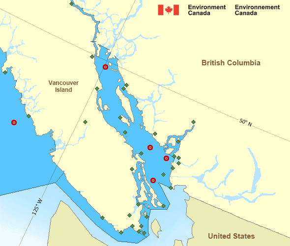
Map of Pacific - Georgia Basin marine weather areas Sentry Shoal - 46131 Halibut Bank - 46146 La Perouse Bank - 46206 Georgia Strait - 46303 English Bay – 46304 Discovery Island Esquimalt Harbour Kelp Reefs Malahat Race Rocks Lightstation Saturna Island Sheringham Point University of Victoria Victoria Gonzales Victoria Int'l Airport Ballenas Islands Campbell River Airport Comox Airport Entrance Island Fanny Island Nanaimo Airport Sisters Islets Estevan Point Port Alberni Tofino Airport Grief Point Howe Sound - Pam Rocks Powell River Airport Sechelt Squamish Airport Point Atkinson Sand Heads Lightstation Tsawwassen Ferry Terminal Vancouver Int'l Airport Vancouver Harbour West Vancouver
Legend:
buoy Buoy
land station Land Station
Ice Conditions

There is no ice forecast issued for this area.

Warnings

Warnings (In effect)

Storm warning in effect

West Coast Vancouver Island South

Issued 10:30 AM PST 21 November 2024

'Storm' force winds of 48 to 63 knots are occurring or expected to occur in this marine area. Please refer to the latest marine forecasts for further details and continue to monitor the situation through Canadian Coast Guard radio or Weatheradio stations.

Synopsis

Technical Marine Synopsis

Issued 10:30 AM PST 21 November 2024 Today Tonight and Friday At 10:30 a.m. PST today departing low located west of the offshore
waters.

At 4:00 a.m. PST Friday deepening low 983 mb located south of
Explorer.
By 4:00 p.m. PST Friday storm 980 mb located off Vancouver Island.

Marine Weather Statement

Issued 10:25 AM PST 21 November 2024 A low pressure centre located west of the offshore waters slowly
departs the region. In its wake, gale to storm force easterlies will
gradually ease today.

The next low moves up the Oregon and Washington coast into Southern
Explorer Friday morning and approaches West Vancouver Island Friday
afternoon. Gale to storm force southerly to southeasterly winds will
develop ahead of the low, while northerly gales are expected in its
wake.

Additionally, strong to gale force outflow winds through mainland
inlets of the North and Central Coasts will continue today and
strengthen to gale to storm force on Friday.

Pacific - Georgia Basin Area

Another Region

Features

WeatherCAN

Download and use the WeatherCAN app on your mobile device

Date modified: