
Documentation on the EPSgrams for NAEFS (North American Ensemble Forecast System) Based on Ensemble and Deterministic Forecasts Site
Purpose
The purpose of this site is to present the EPSgrams images of Ensemble and Deterministic Forecasts issued every day for 352 meteorological stations in North America.
NAEFS (North American Ensemble Forecasting System)
NAEFS is an initiative involving Canada, the United States and Mexico. NAEFS establish meteorological forecasts combining American and Canadian ensemble systems.
Introduction and Description of Ensemble Forecast
The Canadian Ensemble Prediction System
The Canadian Ensemble System is composed of 20 members and 1 control member. The 20 members are based on the Global Environmental Multi-Scale model (GEM). The 20 models don't have the same physical parameterization, assimilation cycle or perturbed observations. Fore more information on Ensemble Forecast system, click here.
The American Ensemble Prediction System
The American Ensemble System is composed of 20 members with 1 control. Each member represents a perturbed forecast. Perturbations come from independent breeding cycles. More details on this system are available at the following links:
Introduction on EPSgrams
An EPSgram image contains from one to four graphs, each one representing the forecast of a single meteorological variable for 15 days. The ensemble forecasts generated every day at 0 UTC and 12 UTC are used. The system generates data every 6 hours for the next 15 days, except for precipitation (every 12 hours SERIES 1). When forecasts are generated every 6 hours, they are available for every day at 0, 6, 12 and 18 UTC. When they are generated every 12 hours, they are available for every day at 0 and 12 UTC.
In each graph of an EPSgram the operational model and the control model of the Canadian system, the American control model and the 40 models of both ensemble system combined are represented. Three EPSgram series are currently available with the following variables :
SERIES 1
- Total Cloud Cover (0 to 10 tenths)
- Precipitation in mm/12hr
- Surface Wind Speed in km/h
- Surface Temperature in °C
SERIES 2
- Relative Humidity in %
- Geopotential at 500mb in decameters
- Wind Speed at 200 mb in knots
- Sea Level Pressure in hPa
SERIES 3
- Thicknesses 1000 - 500 in decameters
In the preceding table all variables (except precipitation) consist of an instant forecast computed at 0, 6, 12 or 18 UTC each day. For example, for temperatures, graphs contain forecast temperatures at 0, 6, 12 and 18 UTC precisely and not forecast temperatures for 6 hour periods. For the variable precipitation in mm/12hr, values entered at 0 and 12 UTC correspond to values forecast for the 12 hour period preceding the entry.
Example of an EPSgram series
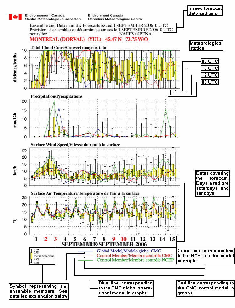

- The yellow rectangle symbol with two vertical lines added, represent the dispersion of the meteorological variable for the members of the ensemble at a given time.
- The upper vertical black line contains the values of the 25% of the members for which the variable is the highest. The upper limit of that line is the value of the highest member.
- The yellow rectangle contains 50% of the members for which the value is intermediary (lower than the upper 25% and higher than the lower 25%). This rectangle is separated by a median. The portion of the rectangle higher than the median contains 25% of the members. The portion under the median contains another 25% of the members.
- The lower vertical black line contains the values of the 25% of the members for which the variable is the lowest. The lower limit of that line is the value of the lowest member.
Utilization
The EPSgram screen appears this way:
EPSgrams for NAEFS Based on Ensemble and Deterministic Forecasts
This screen is divided into 3 lines:
- The first line gives you the option to choose the issue date and time of the EPSgrams. When the screen is started, the current day is the default date at 0 UTC. To the right of those elements you can access the information screen.
- The second line is used to select the meteorological station. To select a station, it is first necessary to select the country, then to choose the station. By default, Canada is the selected country and the ALERT (NU) (WLT) station is selected. It is also possible to choose a station by its 3 to 6 character code if your browser uses JavaScript.
- The last line allows you to change the graph type (EPSgram series). By default, series 1 is given. Note that if JavaScript is turn off in your browser a VIEW button will appear at the right of the graph type. You need to click on that button in order to change the image according to the selections you made.
Starting the site directly at a predefined station:
It is possible to start the site directly at a particular station. To do that, it is necessary to enter the 3 to 6 character code of the station in the URL. For example, to obtain directly the EPSgrams for OTTAWA INTL (YOW), the following URL must be entered: /ensemble/naefs/EPSgrams_e.html?station=YOW
Once entered, this address will be added to the address list of the browser and will always be available.
Note that this option will only work with JavaScript on.
Features
Colour-coded weather alerts

Learn more about weather alerting in Canada
Thunderstorm Outlooks

Find the Thunderstorm Outlook for your area.
- Date modified: